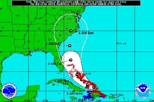
Hurricane Irene continues to grow in strength and ferocity and is now on track to become a Category 4 hurricane, authorities said. Fueled by warm waters and nothing to slow it down, the hurricane is taking a path that will likely skirt Florida and head straight for the Carolinas, with landfall this weekend.
The National Hurricane Center warns that the storm remains unpredictable and is urging East Coast residents to closely track the first major hurricane of the 2011 season as it heads toward the United States so that they can be prepared for impact.
The storm, which is now a Category 2 hurricane, is moving at about 12 mph and is currently north of the Dominican Republic, said National Hurricane Center spokesman Dennis Feltgen in an interview with The Times. Unfortunately, that means “it’s moving into an environment which is very ideal for strengthening. … We expect it to become a Category 4 hurricane as it passes east of central Florida.”
The warm ocean waters and very low wind shear are the two key factors driving the hurricane, he said. High wind shear could help disrupt the storm, scattering it.
“We expect the storm to stay off the coast of Florida, which is good news for Florida. But it’s still looking like it’s going to impact the Carolinas and could make landfall there as a major hurricane.”


