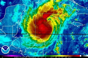
Rina, the 17th named storm and sixth hurricane of the 2011 Atlantic hurricane season, formed on October 23, 2011. Rina rapidly intensified from a tropical depression to a Category 1 hurricane with 75 miles per hour winds in 21 hours. The rapid intensification came due to the extremely warm waters over the western Caribbean. The forecast track and intensity of the storm is very complicated as the models are having a difficult time figuring out what Rina will do.

Rainbow infrared image of hurricane Rina on October 25, 2011. Image Credit: National Hurricane Center
For now, hurricane Rina is expected to gradually strengthen into a major hurricane and push into the Yucatan Peninsula by Thursday. After that, Rina will likely weaken and push to the east or northeast. Everyone from the Yucatan Peninsula, Cuba, and southern Florida should monitor Rina as the storm poses a threat to these regions.
As of 5 a.m. EDT today, hurricane Rina is a Category 2 hurricane with sustain winds of 100 mph. It has a pressure of 975 millibars (mb), and is currently pushing very slowly to the west-northwest at 3 mph. A tropical storm watch has been issued for the Yucatan Peninsula from Chetumal to Punta Gruesa. Meanwhile, a hurricane watch is in effect from north of Punta Gruesa to Cancun. Hurricane warnings will likely be activated later tonight into Wednesday morning as Rina approaches the Yucatan Peninsula.
Here is the forecast track for hurricane Irene from the National Hurricane Center (NHC):
 Five day forecast track of hurricane Rina by the NHC.
Hurricane Rina is currently over the warmest waters in the Atlantic basin. The warm waters are not only at the surface, but extend deep into the ocean. When a storm is over a depth of very warm waters, upwelling cold water is typically never an issue. Instead of upwelling cooler water from the surface, the storm simply upwells warm water which can provide it more fuel to strengthen. Here’s a look at the warm waters in this area:
 Heat content in the Atlantic ocean is the warmest in the Caribbean.
The intensity forecast is rather difficult. Rina is a small storm, so it is capable of developing rapidly in the next 24 hours. The larger the storm, the more time it takes for it wrap around itself, tighten up, and become a stronger storm. However, small storms are also vulnerable to wind shear and dry air which can invade the system rather quickly.
There are three things tropical systems hate: wind shear, dry air, and sea surface temperatures below 80 degrees Fahrenheit. With this in mind, let’s take a look at a few features:
 Water Vapor imagery on October 25, 2011 showing dry air in the Gulf of Mexico. Image Credit: CIMSS
The image above shows water vapor across the United States and the Atlantic basin. The darker the colors, the drier the air. The darker shades of gray and white indicate more moisture in the atmosphere. It is very evident that there is very dry air in the Gulf of Mexico. If Rina pushes into the Gulf, dry air could be a huge problem for Rina. Once Rina begins to drag dry air into the core of the system, weakening will be likely.
 Wind shear analysis on October 25, 2011. Wind shear is fairly high in the Gulf of Mexico. Image Credit: CIMSS
Not only is dry air significant in the Gulf of Mexico, but so is wind shear. Wind shear of around 30 to 50 knots can be found around the gulf, which does not bode well for tropical systems. If Rina wants to intensify, it must do so while it is in the western Caribbean. Once it approaches the Yucatan Peninsula and moves near Cuba, weakening will be very likely as wind shear increases.
The models are having a difficult time figuring out the exact track for hurricane Rina. For now, the models are showing the system pushing into Yucatan, weakening, and eventually moving due east and dissipating. Towards the end of the week, a decent trough, or extended area of low pressure, will push into the eastern United States. If the storm is relatively strong, Rina could “feel” the effects of the trough digging south. If this happens, Rina will likely be pulled to the northeast and merge into the frontal system. However, models show enough weakening that Rina does not feel the pull from the trough, thus staying in the Caribbean and dying out due to high wind shear and dry air intrusion.
Forecast track and especially intensity is still uncertain. Hurricane Rina is expected to become a powerful Category 3 hurricane with 115 mph winds in the next 36 to 48 hours. It is possible the storm could be stronger than that, especially if wind shear and dry air does not enter the system and it stays over the very warm waters in the western Caribbean. If a trough somehow picks up Rina, the storm could impact southern Florida as a weak hurricane or strong tropical storm by the end of the week. Regardless of the track, everyone along the Yucatan Peninsula, Cuba, and southern Florida should keep a close eye on Rina as the storm spins in the western Caribbean. You can get the latest updates on Rina by visiting the National Hurricane Center.


